Here's the latest in my ongoing look at how 2016 is shaping up temperature wise. This includes all data sets up to October 2016, and all the satellite sets (excluding UAH 5.6) for November.

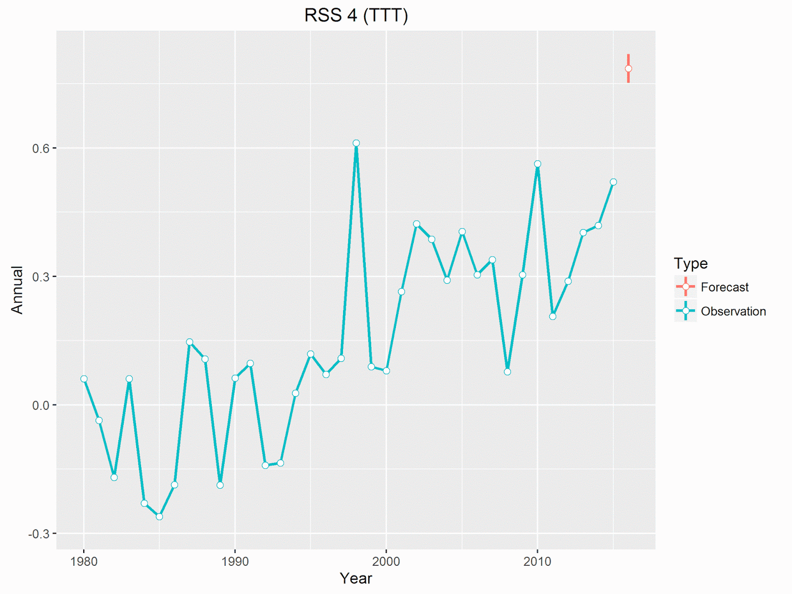
All the satellite sets rose in November, with UAH beta 6 setting a record for November by some way. In fact it beat the record set in 2015 by 0.12 °C. This also means that the 12 month rolling average set a new record, 0.52 °C, 0.04 °C warmer than the peak in 1998. RSS 3.3, was only the second warmest November, losing to the previous record (set in 2015) by 0.07 °C. The current version of RSS 4, for TTT, also set a record for November, beating 2015 by an impressive 0.18 °C.

The projected amount by which each set will beat its previous record haven't changed too much. November saw a small rise in projections for UAH 6 and RSS 4, but a small reduction in RSS 3.3. UAH 6 and RSS 3.3 are now very similar, with both looking to be around 0.2 - 0.4 °C warmer than 1998.

The projected probability of 2016 setting a record hasn't changed much, with the notable exception of UAH beta 6, which now jumps from a 75% chance in October to a 97% chance. I think this is more reasonable than before. With only one month to go UAH beta 6 will have to be -0.02 °C in December, a drop of 0.47 °C from November - not impossible by not very likely.
Roy Spencer agrees that it now seems virtually impossible for 2016 to not be a record warm year in the UAH dataset
,
but then points out that it will probably not be statistically significantly different to 1998 given the uncertainties in the satellite dataset adjustments
.
This is probably true, and it's good to see confirmation that there are uncertainties and that the satellite data set is adjusted.
However, it also seems a little disingenuous - not being statistically different only means there may be a small chance that 1998 was warmer,
but then if every other data set also shows 2016 being warmer than 1998, possibly by bigger margins it becomes much less likely that they are all wrong.
In any event, it really doesn't matter which year was warmer, it will make very little difference to the underlying trends.
One Other Thought
Something David Rose mentioned in his recent Sunday Mail article:
This means it is possible that by some yardsticks, 2016 will be declared as hot as 2015 or even slightly hotter – because El Nino did not vanish until the middle of the year.
Firstly, it's looking very likely that all yardsticks
will be showing 2016 as being warmer than 2015.
Secondly, I'm really not sure what he means by slightly
hotter.
Of the 4 surface data sets I've been looking at, NOAA and HadCRUT are the two likely to be close, currently estimated to be around 0.05 °C warmer than 2015, but may drop a bit over the next two months. The other two, BEST and GISS are both looking like being more than 0.1 °C warmer
Satellite data is currently projected to beat 2015 by even more (remember in the satellite data 2015 wasn't anything like as warm as 1998). All 4 data sets, both the old and the new UAH and RSS, are projected to show 2016 as beating 2015 by around 0.2 - 0.25 °C.
Here's what this looks like for the two latest satellite data sets.

Neither of these suggest 2016 will be only slightly
hotter than 2015.
No comments:
Post a Comment